Teaching Aids Available for the Classroom
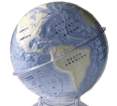
Tactile Hydrographic Globe:
Increased relief globe to share locations of landmasses, water bodies, and other key features of the earth
Increased relief globe to share locations of landmasses, water bodies, and other key features of the earth
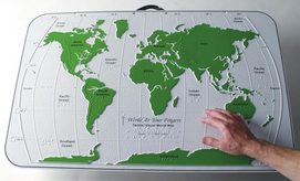
American Printing House for the Blind: Maps and Globes
Source for tactile globe and maps at several different scales of different themes
Source for tactile globe and maps at several different scales of different themes
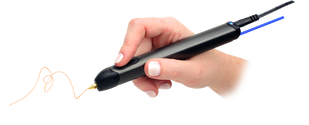
3-Doodler:
3-D printing pen to quickly transform ideas into tactile surfaces/objects
Note: There are many variants of this product from different companies
3-D printing pen to quickly transform ideas into tactile surfaces/objects
Note: There are many variants of this product from different companies
Helpful Links for BVI Education
Library Lyna
3-D Printed Models for STEM educational purposes
Best Practices for Accessibility in Geography
Accessibility analysis of the Geographic discipline with included best practices for adapting geographic lesson plans, Distributed by Portland community College written by Kayaarasi-Rodriguez & Morris
Guidelines for Text Description of Maps
Best practices for converting visual maps to text descriptions
Perkins Scout: Tactile Maps and Teaching
Search engine for BVI resources in many subject areas
Perkins Scout: Teaching Earth Science to BVI Students
Search engine for BVI resources in many subject areas
Braille Authority of North America: Standards for Tactile Graphics
Best practices for transforming visual media to tactile graphics
Thingverse: Geography 3-D Models
Clearinghouse for 3-D printer model files
Scan the World: Geography 3-D Models
Clearing house for 3-D printer model files with many educational applications
Convert Geographic Data to 3-D Models with shp2stl
Guidelines for converting shapefiles into 3-D printer models
